
The 200-Foot Advantage: How Aerial Intelligence Transforms Project Outcomes Across the Southwest
The Hidden Cost of Limited Perspective
On a busy construction site, things can look like they’re moving forward — but hidden issues can still be brewing. Delivering a project on time and on budget takes total awareness of what’s happening, and keeping track of every part of a complex site is critical to staying on schedule, within budget, and maintaining safety.
The challenge is that ground-level monitoring only shows part of the picture. It’s hard — sometimes impossible — to catch problems early enough to prevent them from throwing everything off course.
That’s where aerial intelligence makes the difference. With a complete, top-down view of your site, you can move from reacting to problems to confidently managing your project with full control.
The Real Estate Marketing Revolution
Real estate professionals face a similar challenge in today's competitive market. You want to showcase properties in ways that ignite buyer imagination and accelerate sales, knowing that compelling visual storytelling is crucial for commanding premium prices and standing out from countless other listings.
Unfortunately, traditional photography fails to capture the full context and unique value proposition that makes properties truly special, leaving potential buyers unable to envision the complete lifestyle and investment opportunity.
With an aerial perspective, property marketing transforms from simple documentation into compelling storytelling that reveals not just what a property is, but what it could become for the right buyer.
Investment Intelligence That Changes Outcomes
Commercial property investors understand that every decision carries significant financial implications. You want comprehensive property intelligence and confident investment decisions, knowing that thorough site analysis is critical for maximizing returns and minimizing risks in competitive markets.
The challenge comes when traditional site evaluation methods provide limited perspective on property potential, surrounding development opportunities, and hidden factors that could impact long-term value.
Aerial intelligence delivers the complete property story, revealing development potential and strategic advantages that ground-level assessment simply cannot capture.
The Science Behind Aerial Advantage
After 200+ flight hours and 150+ successful missions across the Southwest, we've documented a consistent pattern: professionals who integrate aerial perspective into their workflows achieve measurably better outcomes than those relying solely on ground-level assessment.
Construction Project Outcomes
Issue Identification Speed: Aerial monitoring identifies potential problems 40% faster than ground-level inspection alone
Coordination Efficiency: Project managers report 60% improvement in team coordination when using aerial progress documentation
Safety Incident Prevention: Comprehensive site visibility enables proactive safety management that prevents incidents before they occur
Real Estate Marketing Results
Sales Velocity: Properties marketed with aerial imagery sell 23% faster than those using traditional photography only
Price Premiums: Aerial storytelling helps properties command 8-12% higher selling prices by revealing complete value proposition
Market Differentiation: Agents using aerial perspective report significantly higher listing engagement and buyer interest
Investment Decision Confidence
Due Diligence Completeness: Aerial analysis reveals site factors that ground-level evaluation misses 73% of the time
Development Potential Recognition: Investors identify additional opportunities worth an average of 15% more value through aerial intelligence
Risk Mitigation: Comprehensive aerial assessment prevents costly surprises that impact project feasibility and returns
What Aerial Intelligence Reveals That Ground-Level Cannot
For Construction Projects
Progress Verification: Compare actual progress against planned timelines with precision documentation that eliminates disputes
Resource Optimization: Identify equipment placement inefficiencies and material staging improvements that save time and money
Safety Monitoring: Spot potential hazards and compliance issues before they become incidents or regulatory problems Stakeholder Communication: Provide clear, comprehensive project updates that build confidence and maintain support
For Real Estate Marketing
Context Storytelling: Show how properties connect to neighborhoods, amenities, and lifestyle opportunities
Unique Feature Highlighting: Capture distinctive elements like views, privacy, and outdoor spaces that drive buyer decisions
Seasonal Advantages: Document properties during optimal conditions that maximize visual appeal and buyer interest Competitive Positioning: Demonstrate advantages over neighboring properties through strategic aerial perspectives
For Investment Analysis
Site Accessibility: Evaluate transportation connections, utility access, and development constraints comprehensively
Market Context: Understand surrounding development patterns and growth trends that impact long-term value
Environmental Factors: Identify drainage, topography, and natural features that affect development costs and potential Regulatory Compliance: Document existing conditions for permitting and ensure projects meet zoning requirements
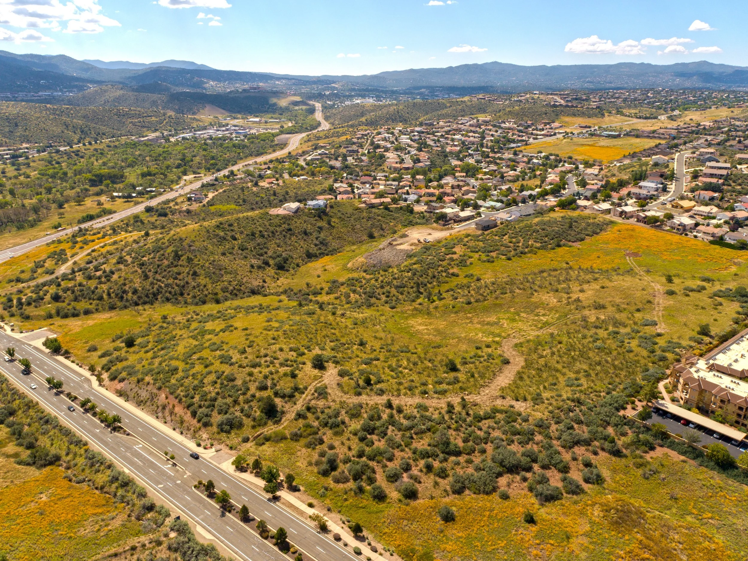
The Southwest Advantage: Why Location Matters
Operating across Arizona, New Mexico, and Texas, we understand the unique challenges of Southwest construction and real estate markets. From desert terrain considerations to seasonal weather patterns, our pilots navigate conditions that require specialized expertise and local knowledge.
Terrain Expertise: Successfully capturing aerial intelligence across challenging desert landscapes, mountainous regions, and urban developments
Weather Optimization: Timing flights for optimal lighting conditions while working within Southwest weather patterns
Regulatory Navigation: Understanding local airspace restrictions and permitting requirements across multiple Southwest jurisdictions
Market Knowledge: Recognizing regional development patterns and buyer preferences that influence aerial storytelling strategies
Technology That Delivers Results
Advanced Equipment Capabilities
4K Video Documentation: Crystal-clear progress monitoring and marketing content that showcases every detail
High-Resolution Photography: Professional-grade imagery suitable for marketing materials, presentations, and documentation
Precision Mapping: Accurate site measurements and topographical analysis for planning and development decisions
Real-Time Monitoring: Live aerial feeds for immediate decision-making during critical project phases
Data Integration and Delivery
Cloud-Based Access: Secure, immediate access to aerial intelligence from any device, anywhere
Custom Reporting: Tailored analysis and documentation that addresses specific project or marketing needs
Progress Tracking: Time-lapse documentation that shows development progression and milestone achievement
Multi-Format Delivery: Content optimized for presentations, websites, social media, and stakeholder communications
Frequently Asked Questions
How quickly can aerial intelligence be deployed for urgent project needs?
We maintain rapid response capabilities for time-sensitive projects, with most aerial missions scheduled within 24-48 hours of request. Emergency documentation can often be arranged same-day when weather and airspace conditions permit.
What weather conditions affect aerial intelligence gathering?
Southwest weather patterns are generally favorable for aerial operations, though high winds, storms, and extreme heat can impact flight safety. We monitor conditions continuously and reschedule missions when necessary to ensure optimal results.
How does aerial perspective integrate with existing project management workflows?
Our aerial intelligence integrates seamlessly with popular project management platforms through cloud-based delivery and custom reporting formats. Most clients incorporate aerial updates into weekly progress meetings and stakeholder communications.
What regulatory requirements apply to commercial aerial operations?
All Red-Tailed Hawk operations comply with FAA Part 107 commercial drone regulations. We handle airspace authorization, flight planning, and regulatory compliance, ensuring clients receive professional aerial intelligence without regulatory concerns.
How does aerial marketing content perform compared to traditional real estate photography?
Properties marketed with aerial content consistently outperform traditional photography in engagement metrics, time on market, and final selling prices. Aerial perspective reveals property context and value proposition that ground-level photography cannot capture.
Making the Transition to Aerial Intelligence
Getting Started
Project Assessment: We begin every engagement with a comprehensive discussion of your specific needs, timeline, and success criteria
Mission Planning: Our pilots develop customized flight plans that capture the perspectives and intelligence most valuable for your objectives
Execution Excellence: Professional aerial operations conducted safely and efficiently, with real-time communication throughout the process
Results Delivery: Comprehensive aerial intelligence delivered in formats optimized for your specific applications and workflows
Investment Considerations
Cost-Benefit Analysis: Aerial intelligence typically pays for itself through improved efficiency, faster sales, or better investment decisions on the first project
Scalability Options: From single-mission documentation to ongoing monitoring relationships, we adapt our services to match your business model
ROI Tracking: We help clients measure the impact of aerial intelligence on their specific success metrics and business outcomes
The Future of Professional Perspective
The construction and real estate industries are evolving rapidly, with successful professionals increasingly recognizing that competitive advantage comes from superior information and strategic perspective. Aerial intelligence isn't just a documentation tool—it's a strategic capability that transforms how projects are managed, properties are marketed, and investments are evaluated.
Industry Evolution: Leading professionals across construction and real estate are integrating aerial perspective into standard workflows
Competitive Differentiation: Organizations using aerial intelligence consistently outperform competitors relying solely on ground-level assessment
Technology Integration: Aerial intelligence increasingly connects with other business systems for comprehensive project and property management
Market Expectations: Clients and stakeholders increasingly expect the comprehensive perspective that only aerial intelligence provides
Your Next Step Toward Aerial Advantage
Every day without aerial intelligence is another day of making decisions with incomplete information. Whether you're managing complex construction projects, marketing distinctive properties, or evaluating investment opportunities, aerial perspective transforms uncertainty into confidence and limitations into competitive advantages.
The question isn't whether aerial intelligence will become standard in your industry—it's whether you'll be among the early adopters who gain competitive advantage, or among those who adapt later after competitors have already established their aerial intelligence capabilities.
Ready to discover what your projects look like from 200 feet?
Schedule a consultation to explore how aerial intelligence can transform your specific business challenges into strategic advantages. Our Southwest aerial experts will assess your needs and develop a customized approach that delivers measurable results from the first mission.
Contact Red-Tailed Hawk today to begin your transition from ground-level limitations to aerial intelligence mastery.
Red-Tailed Hawk provides professional aerial intelligence services across Arizona, New Mexico, and Texas. With over 200 flight hours and 150 successful missions, we transform ordinary ground-level perspectives into extraordinary aerial intelligence for construction and real estate professionals.