

Soaring Above Construction: How Aerial Intelligence Transforms Project Monitoring
The construction site below buzzes with activity—heavy machinery carving new pathways, workers navigating complex terrain, materials flowing like a carefully orchestrated symphony. But from 400 feet above, perched on invisible currents of innovation, a different story unfolds. Welcome to the aerial advantage that's revolutionizing construction monitoring.
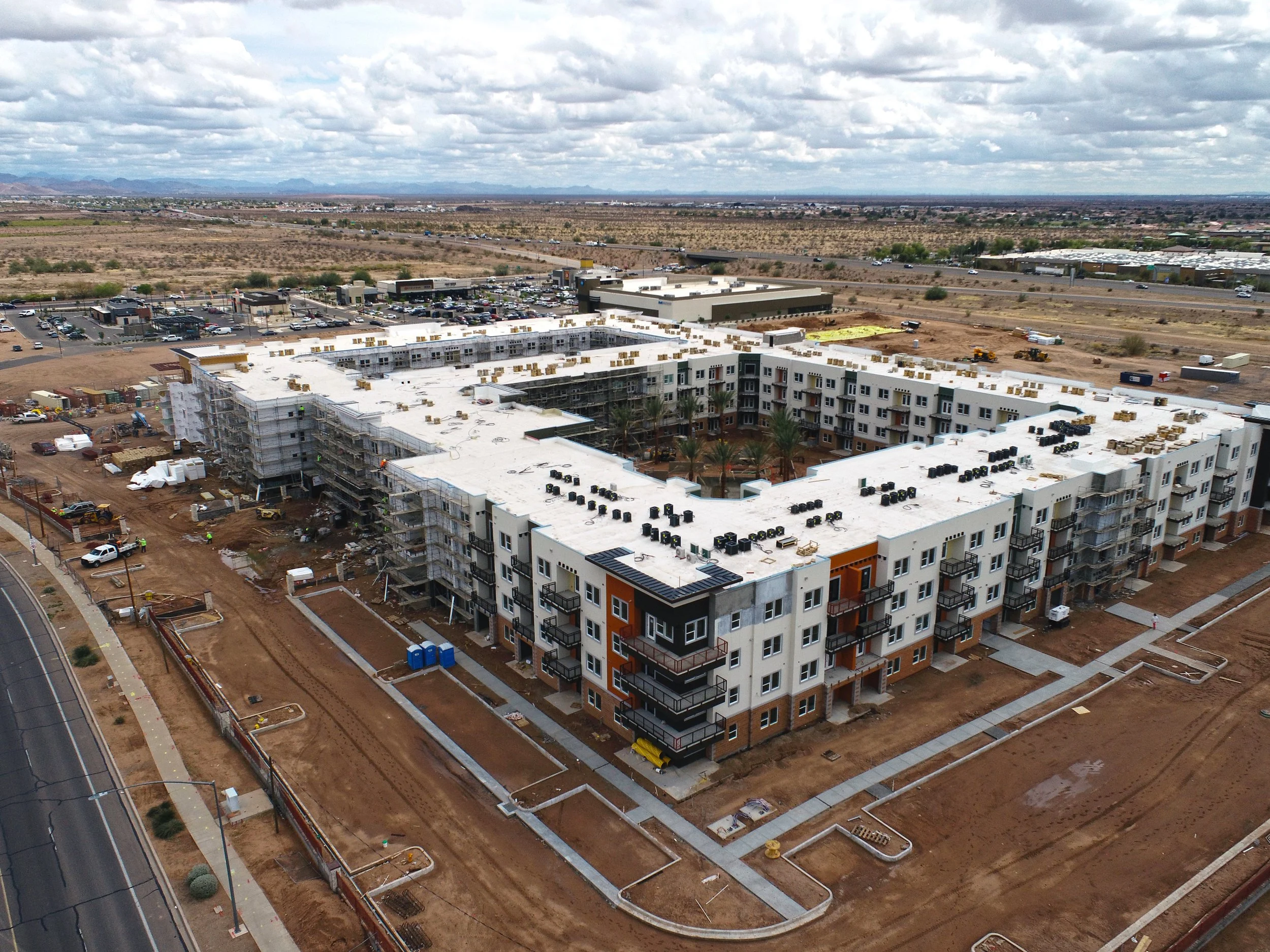
An Apartment Complex Construction Project in Mesa, AZ
Picture this: What once took weeks of ground-based surveying, dangerous climbs up unfinished structures, and countless hours of manual documentation can now be captured in a single flight. Like the keen-eyed red-tailed hawk scanning vast territories with precision, modern drone technology has become the apex predator of construction oversight.
The Vision from Above: Why Altitude Changes Everything
The construction industry has always been a battlefield against time, weather, and uncertainty. But recent research reveals that companies leveraging aerial imagery aren't just gaining a competitive edge—they're rewriting the rules of project management entirely.
The Numbers Don't Lie: Aerial photogrammetry achieves volumetric measurements with almost 99% accuracy, transforming guesswork into precision science. Studies show the accuracy between drone-produced imagery and 3D models surpasses other technologies, with error margins of less than 4 centimeters—that's more precise than most construction tolerances.
But accuracy is just the beginning. The real game-changer? Speed and safety working in perfect harmony.
The Hunter's Eye: Spotting What Ground Crews Miss
Traditional construction monitoring is like trying to understand a novel by reading scattered pages. Ground-level inspections provide detailed snapshots but miss the bigger picture—literally. Drones allow users to get a bird's-eye view of entire projects and reveal concerns that would be impossible to identify during ground-level inspections.
Recent research from construction sites across the globe demonstrates this aerial advantage in action:
Real-Time Problem Detection: Technology managers monitoring dozens of separate subcontractors can now survey sites twice per week using drone surveying, identifying issues like incorrectly placed conduits that impede other subcontractors' progress. What once required armies of inspectors now takes a single aerial sweep.
Safety Revolution: Drones capture high-resolution imagery and videos to identify unsafe conditions such as unstable structures, debris, equipment malfunctions, or improper use of personal protective equipment. In one Santiago, Chile high-rise project, drone imagery identified critical safety issues including lack of guardrails and workers without safety ropes—discoveries that potentially saved lives.
The Territory Advantage: Covering More Ground, Faster
Here's where the red-tailed hawk analogy becomes particularly apt. These magnificent raptors can cover territories spanning several square miles in a single hunting flight. Similarly, modern construction drones are territorial dominators.
Efficiency That Defies Logic: A WingtraOne drone can map a 130-hectare quarry in a single hour's flight, with resolution so detailed you can see a coin lying on the ground and know its exact coordinates to within 1 centimeter. Compare this to traditional surveying methods, and the time savings become staggering.
The Nordic Example: In Norway, road construction teams using traditional methods could cover 3 kilometers of road per day, but with advanced drone technology, they now cover 22 kilometers in the same timeframe—a 700% increase in coverage efficiency.
Beyond Photography: The Multi-Sensor Advantage
Modern construction monitoring isn't just about pretty pictures. Drones equipped with sensors can collect thermal imaging, LiDAR scans, and monitor environmental factors, providing multifaceted data collection that enhances project oversight while improving safety and efficiency.
The Complete Intelligence Package:
Thermal Analysis: Identifying heat patterns in materials and equipment
LiDAR Precision: Creating detailed 3D topographical maps
Environmental Monitoring: Tracking impact on surrounding ecosystems
Progress Documentation: Regular aerial imagery enables project managers to assess construction activity status and compare against project timelines
The Sustainability Connection: Building Greener from Above
Environmental responsibility isn't just good ethics—it's smart business. Drone imagery facilitates energy-efficient building design by analyzing solar exposure to determine optimal solar panel placement and supports implementation of sustainable features like green roofs and rainwater harvesting systems.
The aerial perspective allows project managers to:
Minimize environmental disruption through precise planning
Monitor wildlife habitat protection
Optimize resource usage and reduce waste
Ensure sustainable building features function as intended
The Digital Twin Revolution: When Reality Meets Virtual
The future of construction monitoring lies in creating digital twins—exact virtual replicas of physical construction sites. Research shows that integrating drone imagery into Building Information Modeling (BIM) creates enhanced object recognition capabilities and more precise data collection systems.
The Process in Action:
Weekly Aerial Sweeps: Construction project managers routinely map job sites weekly using UAVs for tracing development, safety inspections, and real-time quality monitoring
3D Model Creation: Data is converted into 3D models via multiple 3D points, giving stakeholders complete 360-degree project insight
Design Verification: Computer-Aided Design (CAD) overlays reveal whether activities have diverged from design plans
The Red-TailedHawk Advantage: Your Project, Elevated
Just as the red-tailed hawk combines exceptional vision with tactical precision, Red-TailedHawk.com brings military-grade aerial intelligence to civilian construction projects. We don't just capture images—we provide actionable intelligence that transforms how you manage, monitor, and master your construction projects.
Our Mission, Your Success:
Precision Mapping: Centimeter-accurate surveys that eliminate costly mistakes
Safety First: Identifying hazards before they become incidents
Progress Intelligence: Real-time insights that keep projects on schedule
Stakeholder Communication: Visual progress reports that speak louder than spreadsheets
Environmental Stewardship: Sustainable practices through aerial monitoring
Ready to Soar?
The construction industry is experiencing a seismic shift toward digital transformation, and aerial monitoring isn't just an advantage—it's becoming essential for competitive survival. The earliest adoption of drones in construction marked a pivotal shift toward digital transformation, leveraging aerial technology to enhance decision-making processes and project outcomes.
The question isn't whether you can afford to invest in aerial monitoring technology. The question is whether you can afford not to.
Contact Red-TailedHawk.com today and discover how our aerial intelligence platform can elevate your next construction project from ground-level guesswork to sky-high precision.
Because when it comes to construction monitoring, the view from above changes everything.
Works Cited
Equinox Drones. "Enhancing Construction Site Monitoring with Unmanned Aerial Vehicles (UAVs)." Equinox Drones, 16 Aug. 2024, equinoxsdrones.com/construction-site-monitoring-using-unmanned-aerial-vehicle/.
"GIS and Drone Imagery Boost Construction Management Efficiency." Esri, 28 Mar. 2022, www.esri.com/en-us/lg/industry/aec/stories/la-cima-case-study.
"An Overview of Drone Applications in the Construction Industry." MDPI, 3 Aug. 2023, www.mdpi.com/2504-446X/7/8/515.
Propeller. "Drones in Construction: Benefits and Uses." Propeller, 10 Apr. 2025, www.propelleraero.com/blog/drones-in-construction-why-they-are-beneficial-and-how-to-use-them/.
"Construction Monitoring and Reporting using Drones and Unmanned Aerial Vehicles (UAVs)." ResearchGate, 2 July 2018, www.researchgate.net/publication/326264559_Construction_Monitoring_and_Reporting_using_Drones_and_Unmanned_Aerial_Vehicles_UAVs.
Surety Bond Professionals. "7 Ways Drone Imagery is Increasing Sustainable Construction." Surety Bond Professionals, 2 Aug. 2024, www.suretybondprofessionals.com/aerial-imaging-sustainability-construction/.
"Six Ways Drones in Construction Add Value." Wingtra, 8 July 2020, wingtra.com/drone-mapping-applications/drones-in-construction-and-infrastructure/.
"Integrating Drone Imagery and AI for Improved Construction Site Management through Building Information Modeling." MDPI, 15 Apr. 2024, www.mdpi.com/2075-5309/14/4/1106.
Ready to gain the aerial advantage? Visit Red-TailedHawk.com or call us today to schedule your consultation. Your project deserves the precision that only comes from above.